Text on video-essay: Sailing to EU ports
At the outset of 2026, Cyprus takes over the presidency of the European Union.
If you leave Cyprus by boat, Europe does not begin immediately.
This work constructs a literal geopolitical table-map in which geography,
rather than politics or economics, determines spatial relations.
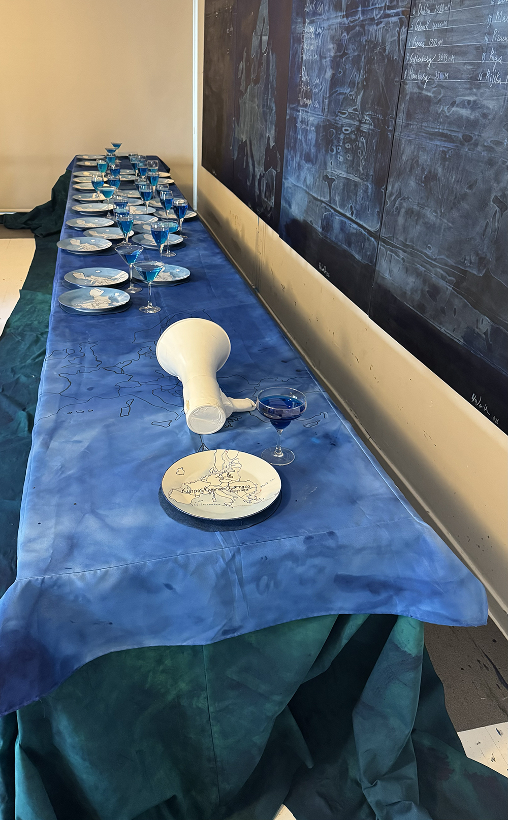
The installation takes the form of a long banquet [παν-κου-ετ] symposium table representing
the 27 EU member states, with Cyprus positioned at its head.
The work reframes the European Union as a shared spatial structure,
Cyprus appears both central as host and peripheral within the wider continental system.
THE GEOGRAPHY TABLE-MAP
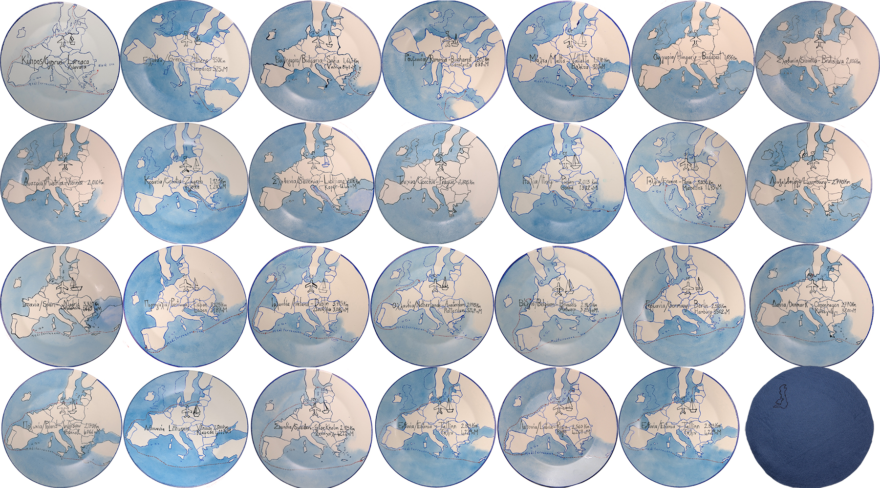
The table becomes a map. Not a symbolic one, but a spatial one.
Each porcelain plate corresponds to a capital city and port.
Each one is inscribed with the exact distance from Larnaca, Cyprus,
in kilometers by air
and in nautical miles by sea.
The plates are positioned according to their actual sea distance.
Not political alignment, not economic power—only measurable geography.
The banquet table is 80cm × 6 .15 meters
The surface is layered with hand-painted seascape tablecloths,
creating a maritime surface.
Each porcelain plate corresponds to a capital city and port.
A cast megaphone is placed at the head of the table, next to the Cyprus plate.
On this table, the plates are 27 in total:
1 for Cyprus,
26 EU member states,
All plates have been hand-painted.
Each plate is inscribed with the exact distances from Larnaca, Cyprus, measured in both kilometers and nautical miles (nM), calculated for both air and sea travel where applicable.
On the tables are also 27 cocktail glasses filled to the rim with a sea-blue cocktail, a mixture of blue liqueur and salted carbonated water, positioned in relation to each EU member state, a measurable,drinkable,navigable field.
3. DISTANCE AS SYSTEM (GEOGRAPHIC STRUCTURE)
The plates are positioned according to their actual sea nautical mile distance from Larnaca, Cyprus.
Eastern Mediterranean & Black Sea proximity
Central European concentration
Western European extension
Atlantic and Nordic regions
Within this system, visually on the table, Cyprus remains structurally isolated at one end of the configuration, while simultaneously positioned as host.
The arrangement of plates on the table follows this same logic:
a spatial translation of maritime travel according to their relative distance from Cyprus.
The nearest EU country from Cyprus by boat is
Piraeus at 525 nM, followed by:
Varna — Bulgaria — 841 nM
Constanza — Romania — 888 nM
Valletta — Malta — 920 nM
Rijeka — Croatia — 1210 nM
Koper — Slovenia — 1246 nM
Genoa — Italy — 1382 nM
Marseille — France — 1475 nM
Valencia — Spain — 1643 nM
Lisbon — Portugal — 2187 nM
Dublin — Ireland — 3084 nM (London — UK — 3200 nM)
Rotterdam — Netherlands — 3249 nM
Antwerp — Belgium — 3254 nM
Hamburg — Germany — 3502 nM
Gothenburg — Sweden — 3693 nM
Copenhagen — Denmark — 3800 nM
Gdansk — Poland — 4066 nM
Klaipeda — Lithuania — 4117 nM
Tallinn — Estonia — 4229 nM
Riga — Latvia — 4229 nM,
and at the very end, the Baltic states,
upto
Helsinki — Finland — 4350 nM
THE MEGAPHONE
An epoxy megaphone cast is placed beside Cyprus.It is positioned pointing toward the European table.
It suggests both connection and distance within the European framework.It raises a question: can Cyprus be heard?The megaphone does not resolve this question.It only makes the condition of amplification visible—without guaranteeing reception.
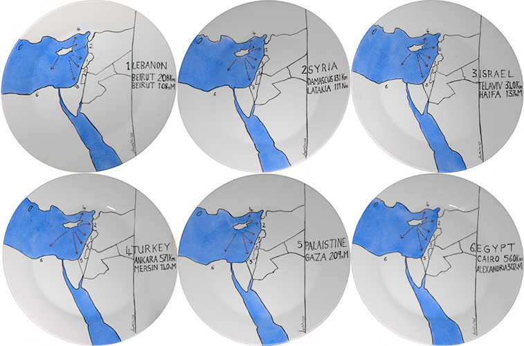
THE NEIGHBORING [SIDE] TABLE
Behind Cyprus, a smaller table is placed at arm’s length, measuring 60 × 120 cmThis table contains the six closest neighboring countries of Cyprus
Lebanon 108nM
Syria 111nM
Turkey 140nM
Israel 137nM
Palestine209nM
Egypt302nM
The distance is not only measured in nautical miles—but in physical reach.
Beirut-Lebanon here is 1/5 the distance from Piraeus-Greece…525nM vs 108NM!
This secondary table holds shot glasses filled with the same blue liqueur mixture.
They are consumed straight, in contrast to the cocktail glasses on the European table,
which are delicately sipped!
CONCLUSION
Within this framework, Europe is not only a political entity, but a maritime field defined by movement, separation, and navigation.
Cyprus is a breathing distance to the Middle East, to the Levant, yet culturally and politically it is European, and therefore part of the European Union.
The act of gathering at the table becomes part of the work itself.
Viewers are invited to join this symposium, both visually and, at the same time, offered a blue cocktail drink.
I’ll be making them myself,
perhaps I’ll name it EUROPA BLUE of the 12 seas
SO Take a seat.
Be part of it